Summer 2022 was difficult in terms of extreme events around the world.
I will start from my home country: Italy. After a months-long drought, on the evening of the 15th of September the Marche region was hit by a self-regenerating storm, a very dangerous type of weather phenomenon, characterized by its ability to feed itself and stay over the same area for hours.
The storm caused very intense rainfall, over 400 mm of accumulated rain over some areas according to the Italian Civil Protection. In meteorology, 1 mm of rain equals 1 liter of water per square metre; this means that, locally, more than 400 liters of water per square meter fell within a few hours! This enormous amount of water has led to the flooding of rivers and streams, causing many casualties. The passage of two smaller storms on September 16th and 17th made the situation even worse. There were then other floods in the following weeks in Campania and Lazio, and also in Sicily a few days later.
Speaking about the causes, high temperature values recorded during the last Summer caused intense heat waves in the Mediterranean Sea, with seawater temperature up to 5°C higher than the average which, by the way, is still ongoing. Together with the atmospheric weather pattern, this provided the storm with huge amounts of water vapor, then discharged on the ground as rain.
The importance of marine conditions is even bigger when considering larger events, such as hurricanes and typhoons. The Atlantic hurricane season is in full swing, with Fiona and Ian both reaching intensity level 4 (the second highest). Hurricane Fiona formed on the 18th of September from a tropical storm transiting over the Gulf of Mexico, which is characterized by very high water temperatures this time of year. The hurricane passed over Puerto Rico on the same day, killing 21 people and leaving half a million people without energy supply. Next, it moved to the Dominican Republic, then moved to Canada, where it caused casualties and an estimated $2 billion in damage. Yes, in Canada.

How is it possible for a hurricane to get so far North? Blame it on the jet stream! The jet stream is an air flow in the atmosphere, located at an altitude of about 10 km, with a speed of around 180 km per hour. In the Northern Hemisphere it passes over Europe, Asia and North America, but is usually not very stable. In fact, it produces undulations, known as Rossby waves from the name of the Swedish-American meteorologist Carl-Gustaf Rossby, having huge effects on the weather. Back to the point: Hurricane Fiona got too close to one of those waves and was carried with the flow up to the coast of Nova Scotia.
As we said, hurricane season is ongoing. Over the last few days we saw images of Cuba and Florida devastated by Hurricane Ian, also a category 4, which caused at least 88 casualties. The affected areas experienced winds around 250 km per hour and several meters high waves. On average, the number of hurricanes and tropical storms has increased in recent decades due to climate change, which is making them more frequent and intense. In addition to human losses, hurricanes cause huge damage; the US National Oceanic and Atmospheric Administration estimated the economic cost of hurricanes to the US between 1980 and 2021 to be more than a trillion dollars.
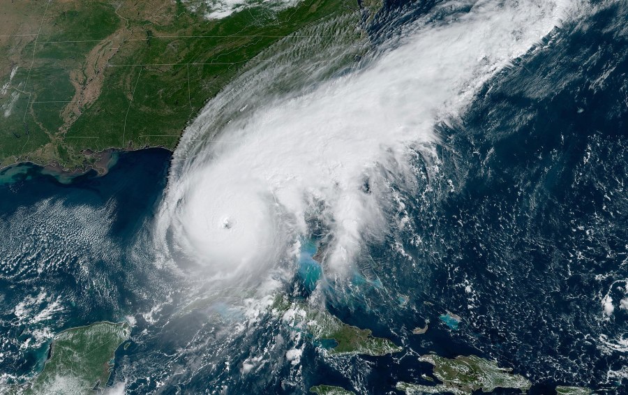
The tropical cyclones in the Pacific Ocean, called typhoons in the area, have also been very active lately. The most noteworthy this year are certainly Hinnamnor and Nanmadol, which reached the category of maximum intensity, before losing strength and landing in Japan and Korea, within weeks of each other, causing casualties and extensive damage. This image of Nanmadol from above makes it clear the size and scope of these cyclones, which can reach 1500 km in diameter (more or less the distance between Barcelona and Belgrade, as the crow flies).

Last but not least, floods have devastated Pakistan recently. The country has been hit by heavy rains since the start of the monsoon season in June. Year 2022 has already been declared by the authorities the wettest year since record started in 1961. The rains were 10 times more abundant than average in some regions and caused River Indus to break leeve. In total, around 10% of the country ended up under water. The damage evaluation is still ongoing, but the event affected more than 30 million people. More than 1600 people died and hundreds of thousands had to leave their homes. The floods have caused huge losses of crops and livestock, sparking fears of a humanitarian crisis even worse than the flood itself.
Many describe these extreme events as belonging to the recent “climate crisis”, caused by human-induced climate change, with ecological, political and social consequences. Human and economic loss is huge and must be tackled, by improving our ability to adapt to extreme events (building infrastructures to protect coastal areas, improving warning systems, reducing flood risk, among many), as well as mitigation policies aimed at reducing greenhouse gas emissions. It costs more not to do that, literally.
Note: The original version of this article can be found here: https://www.noidiminerva.it/estate-estrema/.
